11th International Conference on Archaeological Prospection
bardzo namawiam do zarejestrowania się już teraz (z uwagi na bardzo już ograniczoną liczbę miejsc) – na specjalną sesję otwartą (czyt. po zarejestrowaniu – wstęp wolny) poświęconą archeologii nieinwazyjnej11th International Conference on Archaeological Prospection.
15–19 September 2015, Warsaw, Poland
„The conference aims to provide a forum for the presentation and discussion of latest developments and cutting-edge research in the field of archaeological prospection. It shall cover the entire spectrum of methodology and technology applied to the detection, localization and investigation of buried cultural heritage (aerial photography, airborne laser scanning, hyperspectral imaging, near-surface geophysics, data processing, visualization and archaeological interpretation).
The focus shall be on integrative approaches exploiting the diversity of all data and information necessary for the visualization and interpretation of archaeological and historical monuments, structures and entire archaeological landscapes. (…)”
During the conference an emphasis will put on the importance of archaeological feedback. An open doors session will be dedicated to the topic of geophysical-archaeological cooperation. We also intend to devote attention to the history of archaeological geophysics.
Warto!!! dlatego polecam zainteresowanie się linkiem:
Również z radością donoszę, że zgłosiliśmy organizatorom ww. konferencji wolę prezentacji wyników naszych wspólnych badań APP:Title of the paper:
Archaeological revival of memory of the Great War in Masovia (Poland). The role of LiDAR in setting boundariesof the planned Cultural Park “The Rawka Battlefield (1914-1915) – in memory of war victims”.
Authors: Anna Zalewska, Michał Jakubczak, Jacek Czarnecki[1].Topic: Interpretation and presentation of prospection results
Abstract
Introduction
“When I saw it, I was amazed how complex it is”. “That should be protected. It survived in such condition for a hundred years”. “I was not aware, it is so extensive and uncluttered”. “It is like an masterpiece, so impressive and so meaningful” – those are just few of many expressions of the reactions we have noticed when presenting the LiDAR visualisation of the former World War One battlefield to the general public and to those at the discretion of whom the protection of it is. In our poster are presented the answers for two questions: Why the battlefield was placed in 1914-1915 right in the region of the Rawka and Bzura rivers and what it left? Why an airborne laser scanning technology is so crucial in the process of activating warscape memory and how it can be used to protect sensitive places against disappearance?
The history of the Eastern Front of the Great War falled into oblivion also in Poland – despite the fact, that its substantial operations took place within the present borders of our country (Czarnecki 2014, Zalewska 2013a). The material remains of that part of the total conflict were to the last years not surrounded by planned conservation care. Especially in Masovia (part of the Central Poland) the traces of former battelfieds were not treated as legacies of painful history despite their significant social potential (Zalewska 2013b. 2014) and as such were deprived of protection. In the described context archaeology can become socially important and causative also within the field of memory studies as an institution of cultural memory, which is forging an important return path from cultural forgetting to cultural memory, by retrieving lost objects and defunct information from the past, also the painful one (see Assmann 2008: 97-8).
Depositional processes: the Great War in Masovia (Poland)
Since the autumn of 1914 after defeated Lodz Operations, the Russian 2. Army under the command of General W. Smirnov established a defensive line up in the foreland of Warsaw, between the Bzura estuary to Vistula and Pilica river. Between Sochaczew and Skierniewice, this friontline was based on the Bzura and Rawka, where the Russian Army took advantage of the steepness of the eastern shores of these rivers and created powerful defensive line. However it was not possible in the upper reaches of Rawka. Also at the Bolimow vicinity, because of the marshy land, for almost 15 kilometer Russians were forced to situate defensive line at a distance of 2-3 km from the river. They relied the front line on villages (Sucha, Borzymów, Humin and Wola Szydłowiecka) turned into fortresses. That position became crucial for the Russians in protecting the road to Warsaw placed just 70 km from that battlefield (Fig. 1). During 7 months of heavy fighting, solidly entrenched 9. German Army, commanded initially by Gen. A. von Mackensen and since April 1915 by Prince Leopold of Bavaria, unsuccessfully tried to break the resistance using the most modern weapon at that time, including chemical weapon. The poisonous chlorine was released thrice: in May, June and July 1915 in that perfectly flat almost treeless war-zone. However, even unprepared for such attacks Russians, defended the front and retreated until mid-July 1915 year. Once the area has lost strategic importance, the two belligerents gone leaving behind them ashes and ruines.
What the Great War left in Masovia?
After 100 years that area became the subject of transdisciplinary project “Archaeological revival of memory of the Great War Material remains of the life and death in trenches of the Eastern Front and the condition of the ever changing battelscape in the region of the Rawka and Bzura rivers (1914-2014)”. It is implemented by The Institute of Archaeology and Ethnology of Polish Academy of Sciences, financed by The National Science Centre Poland and supervised by Anna Zalewska, who created the Scientific Team (10 permanent members). Within 12 months of engagement in achieving project’s objectives (the project started in July 2014 and is planned for four years) we have made progress in reaching out different kinds of archival sources about WWI in Masovia. We also conducted interviews and discussions with the inhabitants, museums staff, collectors of war memorabilia, as well as with representatives of institutions, carrying out the protection of this heritage and with those who are afraid of changes connected to establishing the cultural park. Due to the fact that one of the main goals is to activate the persuasive/ causative force of ‘material memory’ (landscape memory) in protecting the unique and fragile remains of positional warfare of WWI – as the crucial element of the project is seen archaeological prospection.
Archaeological studies seen as the prodespositional processes on the former WWI battelscape
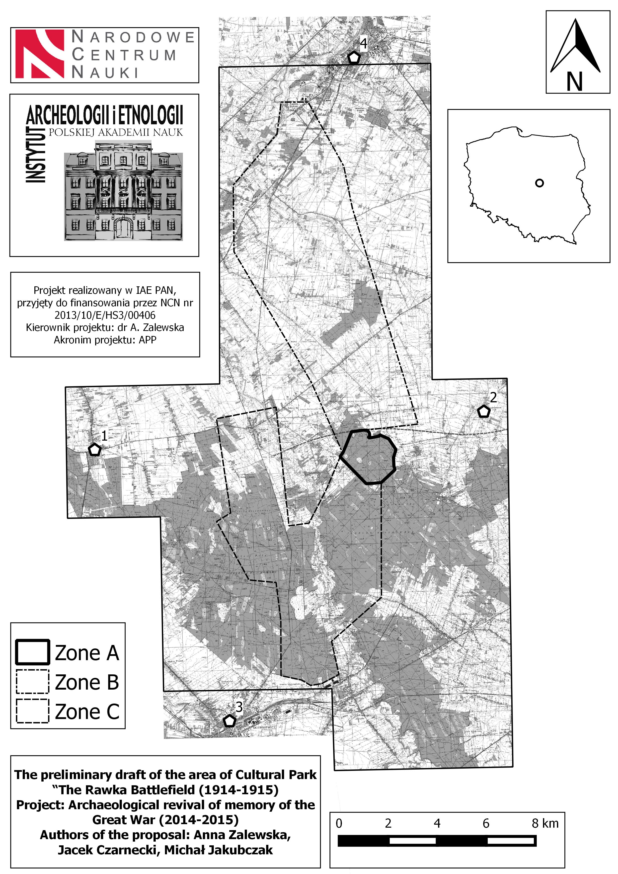
The so far enrolled non-invasive and invasive archaeological methods has revealed the extraordinary preservation of the shaped by the war terrain forms on the study area (Fig. 2): from Nieborów (1) on the West to Miedniewice (2) on the East and from Skierniewice (3) on the South to Sochaczew (4) on the North. By adopting the multidisciplinary approach of “modern conflict archaeology” (after Saunders 2007), we combine the study of written and iconographic sources with field-walking and with geophysical surveys and test-excavation on the selected sites. As very inspiring and worth practicing we have found the new concept of the “AZP_2 project” (for details see: Rączkowski 2011: 154; Jakubczak 2014) which comprises the following actions: a) field-walking, b) aerial reconnaissance and mapping archaeological features, c) geophysical survey (on selected sites), and the d) test trenches (on selected sites recognised via Airborn Lasser Scanning and verified as being either under threat or dense interpretively during field- walking). The AZP_2 strategy as well as the specificity of the remains of destruction (aptly problematized a.o. by González-Ruibal 2008 and Olivier 2008) helped us to avoid the biggest “negative consequence of field-walking in the AZP model” – the reduction in analytical categories.
Till July 2015 the archaeological prospection was done on the 5 AZP areas. The decisions to fully introduce geophysical methods into our project are still in progress. As the most challenging appears the implementation of GPR studies, while the electro resistance and magnetometer survey yielded already very relevant information. In 3 cases the outcomes of geophysical methods resulted in selecting the areas for the invasive research. In sum we have excavated 0,10 acres and the next 0,35 is planned for 2015. The selection of “test tranches” is governed by two criteria: firstly the identification of current threats and secondly the cognitive potential of recognizing the pictures of life and of death in the Great War trenches via material remains. So far, the crucial support in recognizing the specificity of the analysed post-war landscape and in protecting its scattered features was LiDAR.
LiDAR technology in the process of protecting material remains of sensitive places such as gas-scapes
In the process of activating the memory of landscape where a.o. the poisonous gasses were used ALS technology (Airborne Laser Scanning), which peers also through forest cover, appeared invaluable (fig. 3). The results of the ISOK Project (IT System of the Country’s Protection against Extreme Hazards) were enrolled in interpretative process by archaeologists after adjusting them to our needs, since the classification of cloud of points used in archaeology should be lead with different parameters than in case of other types of similar data. The re-classification of cloud of points the Lastools software were used, what significantly increase the quality of DTM (Digital Terrain Model). Various types of DTM visualizations, dedicated to archaeology, are especially useful in the detailed analysis of surface anomalia. In that case the effectiveness of visualizations prepared in Global Mapper, RVT and LiVT software were verified. Definitely the best results were obtained with use of A SVF (anisotropic sky-view factor), which did not exclude effectiveness of other visualizations. Analysis of intensity of laser reflection for plowed fields did not bring expected results. Density of cloud of points characterized as circa 4-6 points per square meter, in that case the transverse angle of scanning does not exceed 25 degrees. The diameter of laser beam spot is maximum 50 centimeters.
In case of presented project, DTM analysis were obligatory followed by the field survey verification. The outcomes of the process of interpretation and falsifiacation of LiDAR augmented the project’s QGIS database which became the basis for choosing the specific areas for detailed studies. The selected areas were implemented to GPS device as raster images. It allowed very accurate verification and was very helpful in documenting the specific antropogenic terrain forms as well as the traces of their damage. One of the most important results of archaeological survey was demarcation of three zones: A – 3,5 km2; B – 55 km2 and C – 42 km2.
Conclussions
The decision to base the core of our research planning on LiDAR visualization (Zalewska, Kiarszys 2014) and to introduce geophysical methods as the significant element of the AZP_2 implementation resulted both from the lack of alternatives (we have not managed so far to reach the archival aerial photographs from 1915 and to-date performance aerial photographs is still ahead of us) and from the encouraging results achieved by Polish archaeologists in using geophysics (e.g. Herbich 2003; Misiewicz 1998). But what is also worth stressing, is the fact that non-invasive methods – especially the crucial from our point of view analysis of interpretations of data from Airborn Laser Scanning – are also as the most causative. Since the presentation of the results of the archaeological analysis of LiDAR (when verified through the field surveys) create the persuasiveness of ‘more visual approach’ (see Rączkowski 2011:155) which is stirring the imagination not only of archaeologists engaged in the process of interpreting the material remains of the forgotten Great War’s Eastern Front but also those who live in the neighborhood of those remains and are decisive when about their persistence towards the future – as it was illustrated in the first lines of that abstract.
Acknowledgments
We would like to thank you to National Science Center for the opportunity of implementing the project “Archaeological revival of memory of the Great War. Material remains of the life and death in trenches of the Eastern Front and the condition of the ever changing battelscape in the region of the Rawka and Bzura (1914-2014)”. The special thanks are dedicated to all members and collaborators of the Scientific Team, who besides ourselves actively contributed to the implementation of the project, especially to those the most engaged during the first and second season in the fieldwork: Bartłomiej Klęczar, Adam Falis, Michał Paczkowski, Mateusz Migal, Witold Migal, Natalia Szymczak, Hubert Dziewiczkiewicz, Jarosław Chrapek, Tomasz Myśliwiec; in the non invasive research: Grzegorz Kiarszys, Marcin Przybyła, Radosław Mieszkowski and in the archival research: Stanisław Kaliński, Dorota Cyngot, Małgorzata Karczewska.
Bibliography
- Assmann, Aleida 2008. Canon and Archive. In: Astrid Erll (ed.), Media and Cultural Memory. Berlin – New York, 97–107.
- Czarnecki, Jacek O wojnę powszechną za wolność ludów: Zapomniany front wschodni [For the common war for the freedom of peoples: Forgotten Eastern Front] “Strzał” 06: 4-7.
- Herbich, Tomasz Archaeological geophysics in Egypt: the Polish contribution. Archaeologia Polona 41: 13–55.
- Jakubczak, Michał 2014. Methods of archaeological survey in the age of IT revolution (unpublished master degree, written in Polish).
- Misiewicz, K. 1998. Metody geofizyczne w planowaniu badań wykopaliskowych. Instytut Archeologii i Etnologii PAN, Warszawa.
- Olivier, Laurent 2008. Le sombre abime du temps: memoire et archeologie. Paris: Seuil.
- Rączkowski, Włodek 2011. Integrating survey data – the Polish AZP and beyond. In: Remote Sensing for Archaeological Heritage Management. Proceedings of the 11th EAC Heritage Management Symposium, Reykjavík, Iceland, 25-27 March 2010. David C. Cowley (ed.). Europae Archaeologia Consilium (EAC), Association Internationale sans But Lucratif (AISBL): 153-160.
- Saunders, Nicholas J. 2007. Killing Time. Archaeology and First World War. Stroud: The History Press.
- González-Ruibal, Alfredo 2008. Time to Destroy. An Archaeology of Supermodernity, „Current Anthropology” 49(2): 247–279.
- Zalewska, Anna 2013a. Relevant and applied archaeology. The material Remains of the First World War: between “Foundational” and “Biographical” Memory, Between “Black Archaeology” and “Conflict Archaeology” [Archeologia stosow(a)na. Materialne pozostałości pierwszej wojny światowej: między pamięcią „fundacyjną” a „biograficzną”, między „czarną archeologią” a „archeologią konfliktu”] „Sprawozdania Archeologiczne”, 65: 9-49.
- Zalewska, Anna 2013b. Roadside Lessons of Historicity. The Roles and the Meanings of the Material Points of References to The Great War and in Shaping Historical Sensitivity and Awareness, „Sensus Historiae” Vol. XIII (2013/4), s. 69-85.
- Zalewska, Anna Prospołeczna, partycypacyjna i „wspólnotowa” archeologia bliskiej przeszłości jako sposób na nadawanie sensu trwaniu (ludzi i rzeczy) oraz jako antidotum na niedostatki wiedzy i trywializację przeszłości [Pro-social, participative and “community oriented” archaeology of the recent past as a way of giving meaning to the existence (of humans and things) and an antidote to trivialisation of the past]. In: “Studia Humanistyczne”, 13/2: 19-39.
- Zalewska, Anna; Kiarszys Grzegorz 2014. Dane wysokościowe jako wsparcie badań archeologicznych Współpraca G. Kiarszys, ProGea, http://szkolenialidar.gugik.gov.pl/szkolenia/materialy-szkoleniowe/karty-zastosowan/.
List of figure captions:
Zalewska- Jakubczak- Czarnecki_Fig. 1
The archival photograph of the German trenches close to Bolimow, manned in 1915 by the soldiers of 61 (8 Pommeranian) Infantry Regiment v.d. Marwitz. Copyright Rodside Lessons Foundation (Fundacja Przydrożne Lekcje Historii).
Zalewska- Jakubczak-Czarnecki_Fig. 2
Potential zones of the WWI material remains’ protection drawn into the visualization of the area of archaeological research planned for the period 2014-2018. Zone A: the area of the best-preserved remains of the positional warfare of the Great War, including ‘No Man’s Land’; zone B: the are of the relatively well preserved remains of the former Battelfield, includin the rear positions; zone C: the strongly transformed area of the former WWI battlefield (archaeological research planned for 2016). Copyright APP.
Zalewska- Jakubczak- Czarnecki_Fig.3
Zone A presented as the outcome of the ALS can be described as stuck in time piece of the Great War appears as unique in scale of Poland or even Europe. It is the best preserved area, in terms of specific forms of terrain left by the events from 1915 such as trenches of diverse features, artillery emplacements, dugouts, weapons stores, field hospitals etc. Unfortunately it is also the area most damaged by black archaeologists (metal detectorists, looters). Copyright APP.
Anna Zalewska (archaeologist, historian)
Institute of Archaeology and Ethnology of Polish Academy of Sciences, Institute of Archaeology UMCS azalew@op.pl
Michał Jakubczak (archaeologist)
Member of the Scientific Team “Archaeological Revival of Memory of The Great War” michał.jakubczak87@gmail.com
Jacek Czarnecki (polemologist, journalist)
Collegium Civitas, Member of the Scientific Team “Archaeological Revival of Memory of The Great War” jaczarny@gmail.com
PS. dziękuję wszystkim, którzy uczestniczyli w poniedziałkowym szkoleniu dot. użytkowania tachimetrów i mam nadzieję na udaną kontynuację terenowej części szkolenia w czwartek 🙂 Szczęśliwie – okazuje się, że nie taki diabeł straszny, a ten o imieniu Topcon jest wręcz intuicyjny..